

Project Information
- Ore Deposit: Epithermal
- Commodity: Gold
- Research Themes: Regional Metallogeny
- Location: Interior Plateau, British Columbia
- Project Status: Completed
- Researchers: Joel Angen, Mana Rahimi, Craig Hart
- Start Date: 2014
- End Date: 2018
BC's Interior Plateau region is difficult to explore because of the lack of outcrop due to the significant thicknesses of glacial till and young volcanic cover. The region is underlain by Stikine Terrane and has the potential to host a variety of arc and intrusion-related mineral deposits. A Geoscience BC defined region known as TREK-Targeting Resources for Exploration and Knowledge was targeted for a $4M, multi-year, integrated earth science program across 24,000 km2 in central BC (NTS 093B, C, F and G). Using new geophysical, geochemical and geological data, MDRU researchers generated a new and significantly improved geological understanding and data framework for the Interior Plateau. This project result of new maps, data and reports is the most significant geological advance and contribution to central BC in several decades, has already led to new mineral occurrence discoveries, and will stand as the definitive work for the next 50 years.
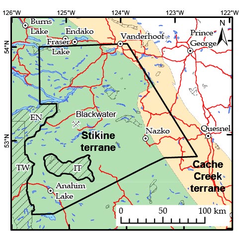
The Interior Plateau region in central BC is highly-prospective for new mineral deposit discovery but is under-explored and difficult to explore effectively because of the significant coverage by glacial till and young volcanic flows. The region has the potential to host a variety of mineral deposit types including porphyry Cu, porphyry Mo and epithermal Au deposits such as Prosperity, Endako and Blackdome, respectively. The discovery of the Blackwater gold deposit (~9 Moz) indicates another deposit type with significant economic potential that can occur in this region. Renewed exploration interest in the Interior Plateau region circa 2013 emphasized the poor quality of the geoscience framework for this region.
This project, supported financially by Geoscience BC, provides new geophysical, geochemical and geological data. Additionally, these new data layers were integrated with existing data, and then re-interpreted, to generate a new and significantly improved geological understanding and data framework for the Interior Plateau Region. The project emphasized those features that control the formation of mineral deposits. The key project objective was to continually improve the geological understanding of the region and to produce new geological maps. This was accomplished through the initial and ongoing data compilations (lithologies, units, age dating, lithogeochemistry, structures, etc…) and followed up with targeted topical studies and field work, ground-truthing, and the acquisition of new age dating, physical property data, lithogeochemistry etc…
IMPACTS
- New geological maps portray a significantly different geological framework for the region than previously considered.
- New age dating confirm the absolute timing of Late Cretaceous gold and copper mineralization and identify several new contemporaneous rock units that are highly prospective exploration targets.
- The MDRU discovery of a volcanic red-bed native copper mineral showing (called “Liesegang“) during field mapping in 2015, was documented in an Angen et al. 2016 Geoscience BC report, and subsequently staked by Parlane Resources Corp. (now iMining.com). Parlane credit MDRU with the acquisition and their subsequent exploration activities (Press Release 15 Nov. 2016). The property was purchased by New Gold Corp. for $2.5M CAD in 2017.
Final Reports
Angen, J. J., Hart, C. J. R., Kim, R. S., and Rahimi, M., 2018. Geology and Mineral Potential of the TREK Area, Northern Interior Plateau, Central British Columbia, Parts of 1:250,000 NTS Sheets 093B, C, F and G; Geoscience BC Report 2018-12, MDRU Publication 411, 175 p. (to accompany Geoscience BC Maps 2017-06-01 and 2017-06-02 /MDRU Maps 12-2017 and 13-2017) Download PDF report 80 Mb
Buckingham, A.J., Core, D.P., Hart, C.J.R., and Jenkins, S., 2017. TREK project area gravity compilation, enhancement filtering and structure detection. Geoscience BC Report 2017-14. Download PDF report 20 Mb Report accompanied by GIS-ready grids, images, shapefiles and georeferenced-PDF maps. Download zip file 281 Mb
Final Map Products
Angen, J.J., Rahimi, M., Hart, C.J.R., Westberg, E., Logan, J.M. and Kim, R., 2017. Bedrock geology, TREK project area, northern Interior Plateau, central British Columbia; Geoscience BC Map 2017-06-01 and MDRU Map 12-2017, scale 1:250 000. Download PDF map 10 Mb Map accompanied by GIS files Download zip file 1.3Gb
Angen, J.J., Rahimi, M., Hart, C.J.R., Westberg, E., Logan, J.M. and Kim, R., 2017. Aeromagnetic correlation with bedrock geology, TREK project area, northern Interior Plateau, central British Columbia; Geoscience BC Map 2017-06-02 and MDRU Map 13-2017, scale 1:250 000. Download PDF map 5 Mb
Visit the Geoscience BC TREK page for additional map products at: http://www.geosciencebc.com/s/TREK.asp
Posters and Interim Reports
Rahimi, M., Hart, C.J.R., and Angen, J.J., 2017. Extracting regional structural features from airborne geophysical data in the TREK project area, central British Columbia. Poster. Download PDF poster 4 Mb
Rahimi, M., Hart, C.J.R., and Angen, J.J., 2017. Application of geochemical datasets for geological mapping, TREK project area, central British Columbia. Poster. Download PDF poster 4 Mb
Buckingham, A., Core, D.P., Hart, C.J.R., and Jenkins, S., 2017. Gravity compilation, enhancement filtering, and semi-automated structural framework detection, TREK project area, central British Columbia. Poster. Download PDF poster 22 Mb
Angen, J.J., Logan, J.M., Hart, C.J.R. and Kim, R., 2016. TREK geological mapping project, year 2: update on bedrock geology and mineralization in the TREK project area, central British Columbia (parts of NTS 093B, C, F, G); in Geoscience BC Summary of Activities 2015, Report 2016-1, p. 1–16. Download PDF report 3.2 Mb
Angen, J.J., Westberg, E., Hart, C.J.R., Kim, R. and Raley, C., 2015. TREK geology project: recognizing Endako Group and Chilcotin Group basalts from airborne magnetic data in the Interior Plateau region, south-central British Columbia (NTS 093B, C, F, G); in Geoscience BC Summary of Activities 2014, Geoscience BC, Report 2015-1, p. 21–32. Download PDF report 6 Mb
Angen, J.J., Hart, C.J.R., Logan, J.M., Kim, R., and Rahimi, M., 2016. TREK Mapping Project Year 2: A Structural Framework for the northern Interior Plateau. Poster. Presented at Exploration RoundUp 2016. Download PDF poster 8 Mb
Looby, E., Gregory, M.J., Hart, C.J.R., Petersen, M., and Lipske, J., 2014. The geology of the Blackwater epithermal Au-Ag deposit. Download PDF poster 16 Mb
Clifford, A. and Hart, C.J.R., 2014. Targeting Resources through Exploration and Knowledge (TREK): Geoscience BC’s newest minerals project, Interior Plateau Region, central British Columbia (NTS 093B, C, F, G); in Geoscience BC Summary of Activities 2013, Geoscience BC, Report 2014-1, p. 13–18. Download PDF report 2 Mb
MSc Thesis
Kasalka Group volcanic rocks and associated hypabyssal porphyrytic intrusions are preferential exploration targets. The geology, geochemistry and geochronology of the Kasalka Group is the focus of an MSc thesis completed by Rachel Kim. These Kasalka and equivalent Late Cretaceous volcanic rocks are directly related to, and host, the Blackwater, Newton and Capoose deposits. They are very sparsely mapped throughout the study region, however because their lithologies are similar to Eocene volcanic rocks, it is likely that they are underrepresented on the current maps.
Evolution of Late Cretaceous Kasalka Group volcanics, Nechako Plateau, central British Columbia
Rachel S.Y. Kim, MSc thesis, 2020
Abstract: As new mineral deposits located at or near-surface becomes exhausted, innovations in exploration are required to ensure the future supply of mineral resources. One of these innovations includes the examination of under-explored regions. The discovery and development of the Blackwater Au-Ag deposit has brought about renewed interest in the Nechako Plateau region. The mineralization at Blackwater is hosted in Late Cretaceous volcanic rocks, that are interpreted to be a part of the Kasalka Group. Historic work and mapping suggest that the Kasalka Group volcanic rocks crop out across the Nechako Plateau region, however, limited data is available for their timing and field descriptions bear strong similarities to other volcanic packages in the region. Furthermore, their context and association with mineralized deposits are limited to the areas immediately proximal to known deposits, and the respective impact on regional metallogeny is not constrained. Detailed and regional mapping, along with multi-faceted sample analyses has allowed for the identification and description of distinct lithologies of the Kasalka Group. High-precision geochronology confirms and identifies several pulses of Kasalka Group volcanism across the Nechako Plateau through Late Cretaceous time, between 82 and 63 Ma. Lithogeochemical characterization has also identified two main compositional groups: a trachyandesite intermediate suite and a high-silica felsic suite. Both compositions may be petrogenetically related, and are also geochemically distinct from older and younger volcanic packages in the region. Integration of age and geochemistry provides key insights to the tectonic setting and provenance of melts that produced the Kasalka Group volcanic rocks. A potential driving factor for Kasalka Group volcanism may be post-subduction melting in continental crust during middle to Late Cretaceous time, instead of a typical subduction-related arc configuration as observed through the Jurassic or along the Coast Plutonic Complex through Cretaceous to Eocene time. Post-subduction crustal thickening may induce melting and result in arc-like volcanic rocks in areas without active subduction or arc magmatism. Similarities to volcanic rocks produced in subduction-related arc settings may indicate that post-subduction magmatic processes in the Cordillera in British Columbia may serve a larger role in the tectono-magmatic evolution and mineral endowment than previous interpretations suggest.
Download thesis at: https://open.library.ubc.ca/cIRcle/collections/ubctheses/24/items/1.0394058
Kim, R.S., Angen, J.J., and Hart, C.J.R., 2017. New U-Pb age constraints and lithogeochemical classification for Late Cretaceous volcanics in the TREK project area, central British Columbia. Poster. Presented at BC TREK Day 2017. Download PDF poster 4.6 Mb.
Kim, R.S., Hart, C.J.R., Angen, J.J. and Logan, J.M., 2016. Stratigraphic and lithological Constraints of late Cretaceous volcanic Rocks in the TREK project area, central British Columbia (NTS 093E). Poster. Presented at Exploration RoundUp 2016. Download PDF poster 5 Mb
Kim, R., Hart, C.J.R., Angen, J.J. and Westberg, E., 2015. Characterization of Late Cretaceous volcanic suites in the TREK project area, central British Columbia (NTS 093F, K); in Geoscience BC Summary of Activities 2014, Geoscience BC, Report 2015-1, p. 33–40. Download PDF report 3 Mb
Kim, R.S., Hart, C.J.R., Angen, J.J., and Westberg, E., 2015. Characterization and stratigraphic framework for Late Cretaceous Kasalka Group volcanics, northern TREK Project area, central British Columbia. Poster. Presented at Exploration RoundUP 2015. Download PDF poster 3.3 Mb.
For more on the TREK project, visit the Geoscience BC TREK page at: http://www.geosciencebc.com/s/TREK.asp