
Project Information
- Ore Deposit: Epithermal, Porphyry
- Commodity: Copper, Gold
- Research Themes: Regional Metallogeny
- Location: west-central British Columbia
- Project Status: Active
- Researchers: Joel Angen, Mana Rahimi, Craig Hart
- Start Date: 2016
- End Date: 2018
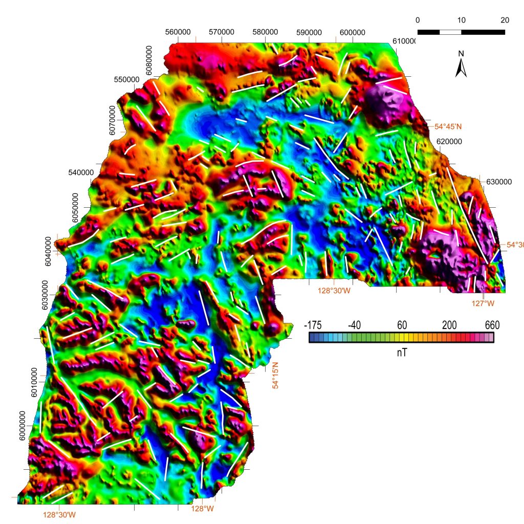
The Skeena Arch in west-central BC hosts porphyry Cu-Au occurrences and other mineralization but has attracted only limited exploration due in part to the poor quality of the existing 40-year-old structural and geological framework. Using high-resolution aeromagnetic data collected by Geoscience BC, field mapping and ASTER imagery, MDRU researchers are adding significant geological value to the SeArch project area to promote exploration interest.
The Skeena Arch in west-central BC refers to the uplifted, pre-Middle Jurassic northeast-trending region that spans the width of Stikine Terrane. Western Skeena Arch in west-central BC hosts porphyry Cu-Au occurrences and other mineralization styles including several past-producing mines. However, this region has attracted only limited exploration due in part to the poor quality of the structural and geological framework – the last systematic mapping was published in 1976 at 1:250,000 scale. High-resolution aeromagnetic data collected by Geoscience BC provides a basis to add significant geological value to the Search project area to promote exploration interest in west-central British Columbia.
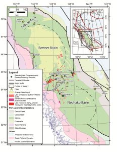
Search project area outlined in grey.
Field mapping and data compilations will be integrated with interpretations from geophysical data. A new regional structural framework and regional and 1:50k bedrock geological maps (NTS 093L/13) will be generated, and augmented by establishing the age of mineralized intrusions to contribute to establishing effective exploration targeting decisions and opportunities.
Maps
J.J. Angen, J.L. Nelson, M. Rahimi and C.J.R. Hart, 2019. Bedrock Geology, Search Phase 1 Project Area, western Skeena Arch, west-central British Columbia. Parts of 1:250 000 NTS sheets 093L and 103I, 1:150 000. Available as Geoscience BC MAP 2019-03-01, MDRU MAP 17-2018, and BCGS OPEN FILE 2019-07.
J.J. Angen, M. Rahimi, J.L. Nelson and C.J.R. Hart, 2019. Aeromagnetic Correlation with Bedrock Geology, Search Phase 1 Project Area, western Skeena Arch, west-central British Columbia. Parts of 1:250 000 NTS sheets 093L and 103I, 1:150 000. Available as Geoscience BC MAP 2019-03-02, MDRU MAP 18-2018, and BCGS OPEN FILE 2019-08.
J.J. Angen, M. Rahimi, J.L. Nelson and C.J.R. Hart, 2019. Mineral Mapping using ASTER Data, Search Phase 1 Project Area, western Skeena Arch, west-central British Columbia. Parts of 1:250 000 NTS sheets 093L and 103I, 1:150 000. Available as Geoscience BC MAP 2019-03-03 and MDRU MAP 19-2018, and BCGS OPEN FILE 2019-08.
Reports
Angen, J.J., Nelson, J.L., Rahimi, M., and Hart, C.J.R., 2017. Mapping in the Tatsi and Zymo ridge areas of west-central British Columbia: Implications for the origin and history of the Skeena arch. In: Geological Fieldwork 2016, British Columbia Ministry of Energy and Mines, British Columbia Geological Survey Paper 2017-1, p. 35-48.
Rahimi, M., Angen, J.J. and Hart, C.J.R., 2018. Application of ASTER data to identify potential alteration zones on Microwave ridge, northeastern Search project area, west-central British Columbia (part of NTS 093L); in Geoscience BC Summary of Activities 2017: Minerals and Mining, Geoscience BC, Report 2018-1, p. 7–22.